Natural Resources Research & Management
Natural Resources Research & Management
Geographically isolated wetlands (GIWs) are important landscape features for a wide range of ecological processes. They serve as habitats for diverse plant and animal communities, improve water quality, store water during drought, and accumulate material. Many of these wetland functions are related to the presence of water and patterns of inundation. Therefore, understanding GIW inundation patterns is key to understanding wetland function.
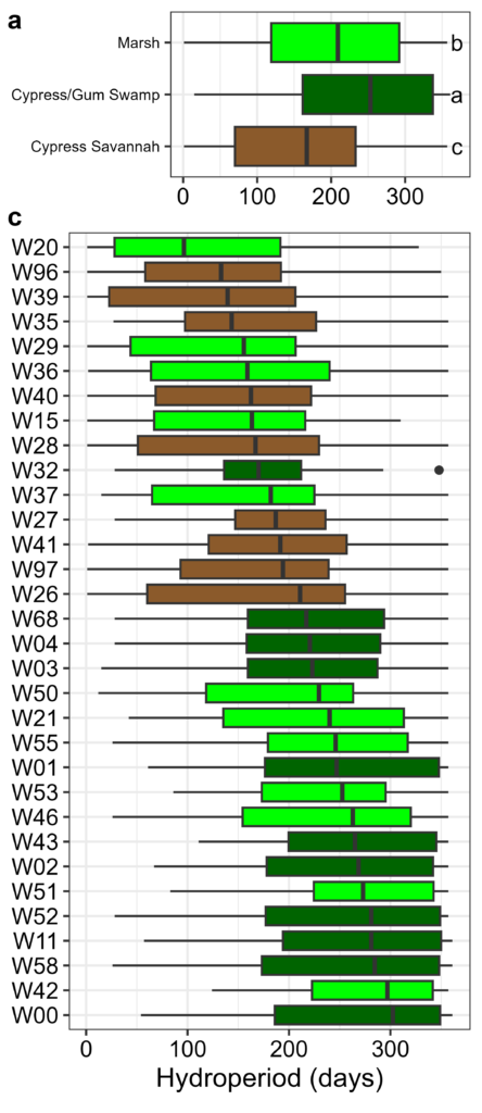
There are over 10,000 GIWs within the 1.5 million acres of Dougherty Plain in the Southeastern Coastal Plain. GIWs tend to be small but collectively make up 5% (75,000 acres) of the land cover in the region. At Ichauway (~29,000 acres), there are over 100 GIWs that comprise 3% (900 acres) of the property. GIWs across Ichauway are classified by their vegetation community, including grassy marshes, forested swamps, and cypress savannahs.
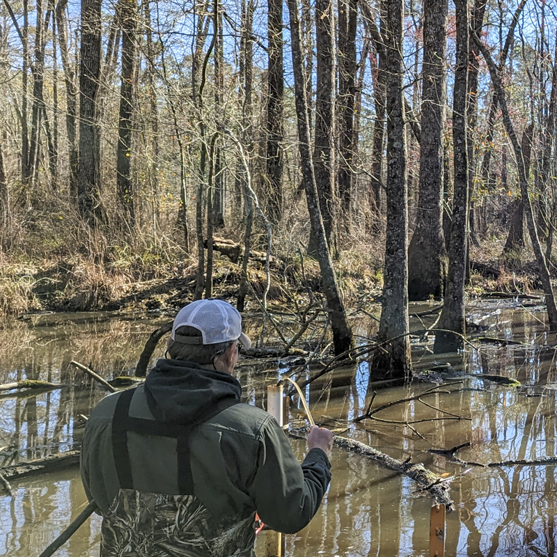
Staff gauges, a hydrologic tool that measures surface water height, were installed in 32 GIWs in 1994 and measured every 2 weeks continuously, resulting in a dataset spanning 30 years. We analyzed these data for patterns over time, including seasonality and year-over-year patterns. Our results show inundation is more frequent in the winter through the early summer, and dry conditions more frequent in the mid-summer through the fall.
We also investigated each wetland’s hydroperiod, or the number of days of GIW inundation in a year. Hydroperiods were the longest in the swamps and shortest in the savannahs. Interestingly, almost every GIW experienced hydroperiods over the 30-year record of 0 days and 365 days, highlighting the extreme conditions over time and the influence of climate variability on GIWs. There is a strong correlation between annual drought intensity, as determined by the commonly used Palmer Drought Severity Index, and average hydroperiod across GIWs.
Our analysis highlights the value of long-term data. The ability to look back in time across so many sites is rare in ecology. This also sets the stage for future work to investigate the effect of hydroperiod on GIW function. The analysis of historical conditions will serve as a baseline to evaluate future hydroperiods from these GIWs and inform new research and understanding of the importance of hydroperiod on GIW function.
Marzolf NS, Clayton BA, Golladay SW, et al (2026) Long-Term Patterns of Geographically Isolated Wetland Inundation and Hydroperiods from the Gulf Coastal Plain. Wetlands 46:53. doi: 10.1007/s13157-026-02068-1
Nick Marzolf, nick.marzolf@jonesctr.org
Geographically isolated wetlands (GIWs) are important landscape features for a wide range of ecological processes. They serve as habitats for diverse plant and animal communities, improve water quality, store water during drought, and accumulate material. Many of these wetland functions are related to the presence of water and patterns of inundation. Therefore, understanding GIW inundation patterns is key to understanding wetland function.
There are over 10,000 GIWs within the 1.5 million acres of Dougherty Plain in the Southeastern Coastal Plain. GIWs tend to be small but collectively make up 5% (75,000 acres) of the land cover in the region. At Ichauway (~29,000 acres), there are over 100 GIWs that comprise 3% (900 acres) of the property. GIWs across Ichauway are classified by their vegetation community, including grassy marshes, forested swamps, and cypress savannahs.
Staff gauges, a hydrologic tool that measures surface water height, were installed in 32 GIWs in 1994 and measured every 2 weeks continuously, resulting in a dataset spanning 30 years. We analyzed these data for patterns over time, including seasonality and year-over-year patterns. Our results show inundation is more frequent in the winter through the early summer, and dry conditions more frequent in the mid-summer through the fall.
We also investigated each wetland’s hydroperiod, or the number of days of GIW inundation in a year. Hydroperiods were the longest in the swamps and shortest in the savannahs. Interestingly, almost every GIW experienced hydroperiods over the 30-year record of 0 days and 365 days, highlighting the extreme conditions over time and the influence of climate variability on GIWs. There is a strong correlation between annual drought intensity, as determined by the commonly used Palmer Drought Severity Index, and average hydroperiod across GIWs.
Our analysis highlights the value of long-term data. The ability to look back in time across so many sites is rare in ecology. This also sets the stage for future work to investigate the effect of hydroperiod on GIW function. The analysis of historical conditions will serve as a baseline to evaluate future hydroperiods from these GIWs and inform new research and understanding of the importance of hydroperiod on GIW function.
Marzolf NS, Clayton BA, Golladay SW, et al (2026) Long-Term Patterns of Geographically Isolated Wetland Inundation and Hydroperiods from the Gulf Coastal Plain. Wetlands 46:53. doi: 10.1007/s13157-026-02068-1
Nick Marzolf, nick.marzolf@jonesctr.org